
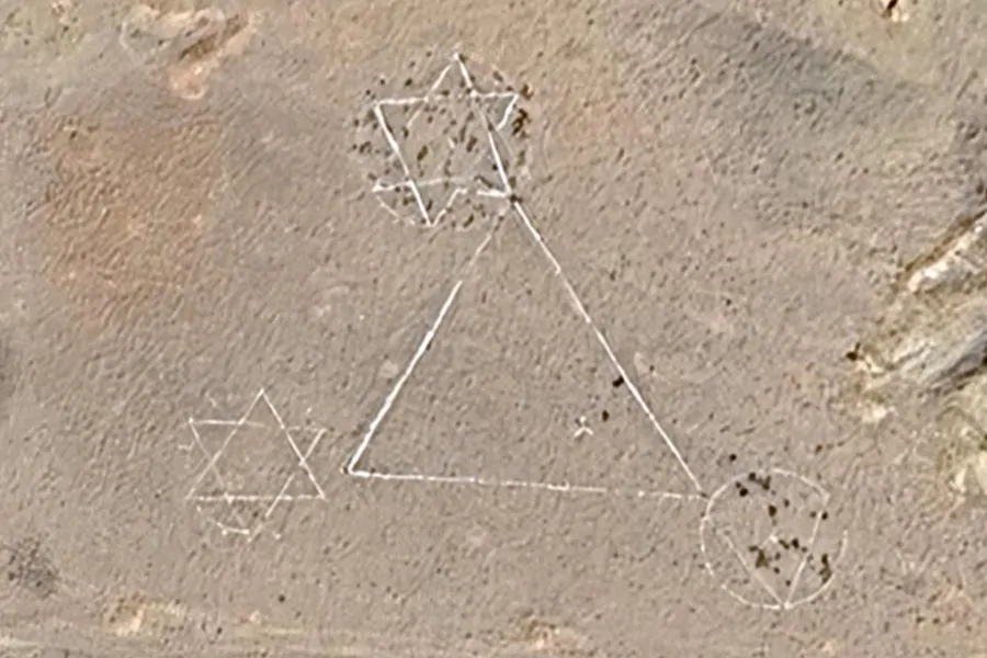
A satellite image from Google Maps went viral today (Monday) after revealing two large Star of David symbols etched into the ground near an Iranian missile base in the city of Khomein.
The discovery ignited a flurry of conspiracy theories across social media — ranging from claims of an Israeli plot to suggestions that it might be an Iranian provocation. Among the commentators was Iranian opposition journalist Walid, who noted that most Iranian users responding to him believed the markings were military training targets. According to Walid, the symbols are not new and were not created in response to the current war.
پرسش دریافتی: این علامتها چی هستند در جنوب غربی شهر #خمین؟ شبیه ستاره داوود روی پرچم اسرائیل به نظر میان.
اینجا روی نقشه:https://t.co/N3JPhpHS1q#iran #israel pic.twitter.com/FdbCCZUlRVעוד באותו הנושא
- Israel Strengthens Global Alliances Amid Regional and International Challenges
- Beyond the Conventional: Haredi Soldiers and Wives of Warriors Stand with the IDF
- Hostages No More: IDF Returns Two Fallen Heroes from Gaza in Daring Operation
- Freed Hostage Turns Her Pain Into Strength at the UN Security Council
— Vahid Online (@Vahid) June 30, 2025
What’s Behind the Symbols?
Additional satellite images from Google Earth indicate the symbols have been present since at least 2024, suggesting they predate the latest conflict. It’s likely the site is an old Iranian military training ground where the symbols were painted as missile test targets — a tactic Iran has used before with similar imagery.
Back in 2017, Israel’s ambassador to the UN, Danny Danon, presented satellite images showing that Iran had used Star of David targets for ballistic missile tests. And in 2010, an image surfaced showing a Star of David on the roof of an Iran Air building in Tehran — reportedly constructed by Israeli engineers in the 1970s, prior to the Islamic Revolution.